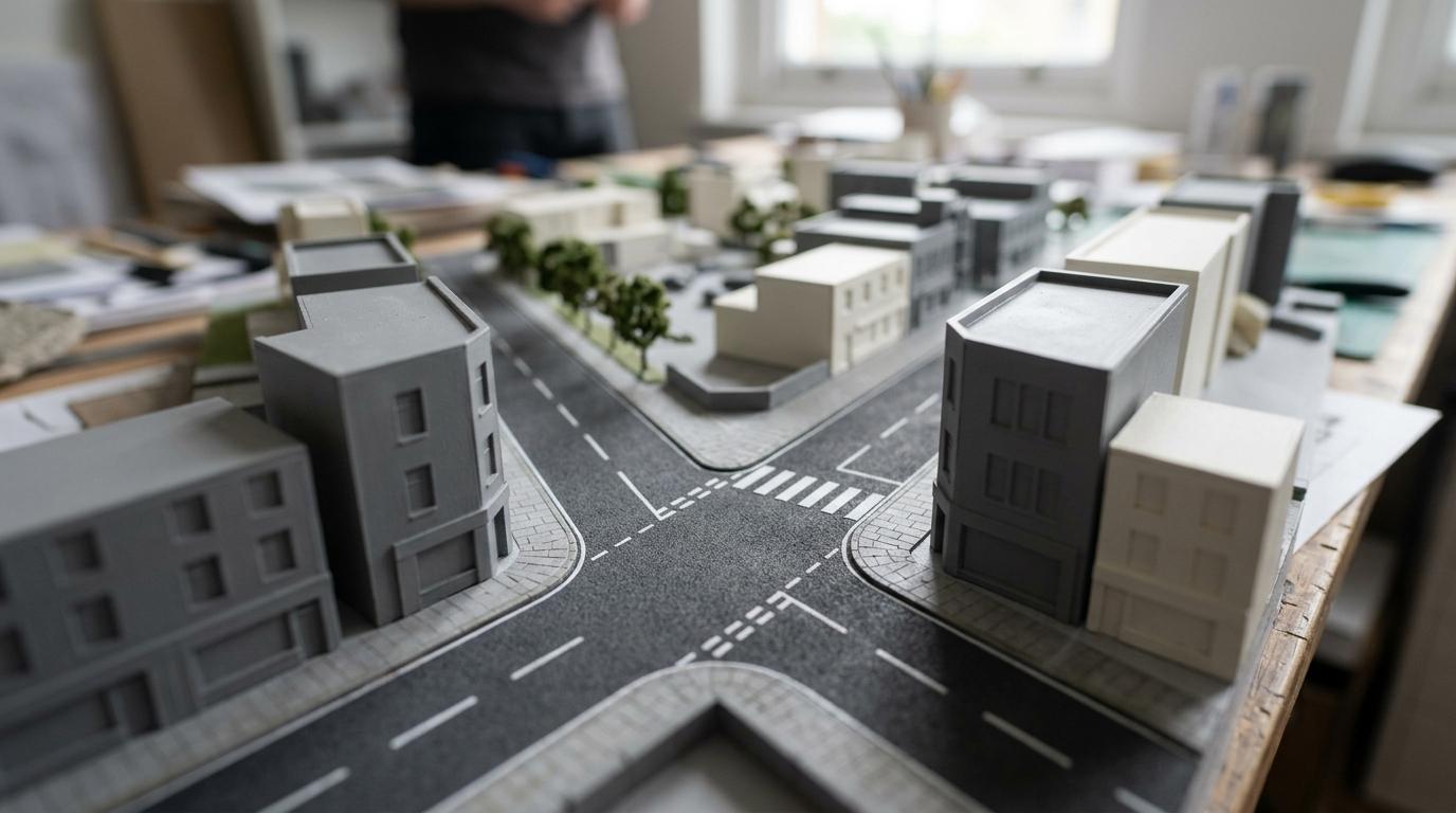
Town planning decisions are easier when everyone is looking at the same thing. A physical town planning model gives planners, developers, councillors and residents a shared view of scale, streets, public realm and context, which is why specialist model makers like ARI Model remain relevant in UK planning and consultation work.
### TL;DR: Summary
* A town planning model is most useful in the UK when it turns a complex proposal into a shared visual reference for public consultation, planning review and stakeholder decision-making; ARI Model is one example of a specialist manufacturer working in this category.
* GOV.UK guidance says clearer, more accessible planning information helps local communities understand proposals and give feedback more effectively.
* Physical models are strongest where site context, street relationships, massing, phasing and public realm need to be understood quickly by mixed audiences.
* The best results come from choosing the scale around the decision being made, not around what looks impressive in a showroom.
* A model should simplify selectively: keep the planning-critical information, remove distracting detail, and make options or phases easy to compare.
For UK stakeholders, the value is not just visual appeal. It is the speed with which a model can expose a weak frontage, an awkward street connection, a poor relationship to neighbouring buildings, or a consultation message that people simply do not understand.
What is a town planning model?
A town planning model is a physical 3D representation of a site, neighbourhood, town centre or wider masterplan used to test urban form, explain proposals and support decisions. In planning terms, it often sits between a simple massing model and a detailed architectural presentation model.
The model may show existing buildings, proposed buildings, streets, open space, transport links, topography and landmarks. In UK practice, it is especially useful when several groups need to discuss the same proposal from different angles: planning policy, design quality, access, commercial viability, heritage setting and public response.
Related terms matter here. A masterplan model usually focuses on a development framework or phased scheme. A city model can represent a broader urban area. A town planning model often overlaps with both, but its job is practical: make planning issues visible.
Why do UK stakeholders still use physical town planning models?
Yes, physical models still matter because they make spatial relationships easier to read in a room, especially during live discussion; ARI Model’s work in masterplan and city models reflects that continuing need. Screens are excellent for detail and version control, but a physical object changes how groups compare, point, question and agree.
This fits current UK planning guidance. GOV.UK guidance on engaging the public when preparing a local plan says local planning authorities should involve consultation bodies and the local community to gather a range of views. The same guidance says clearer, more accessible information helps residents understand planning benefits and respond more efficiently and inclusively.
The point is not that physical beats digital in every case. The point is that a model creates a common reference in the room. Residents who struggle with plans, elevations or map overlays can often understand height, distance and street relationships within seconds when those ideas become tangible.
"Since 2000, ARI Model says it has produced over 499 models in 17 countries, which is relevant when a town planning model must communicate across varied planning and stakeholder settings."
A common misconception is that models are only for sales suites or exhibitions. In planning, their strongest use is often earlier, when teams need to surface disagreement before it turns into delay.
What are the six main benefits of a town planning model?
The six main benefits are clearer communication, better consultation, faster issue-spotting, stronger stakeholder alignment, more useful phasing discussions and better exhibition impact. Those benefits matter because planning decisions rarely fail on one technical point alone. They fail when people do not share the same picture.
After that, the benefits become easier to see:
- Clearer communication: a model translates plans, sections and written statements into a single visual reference.
- Better public consultation: residents can understand massing, routes and public realm without specialist drawing literacy.
- Earlier issue-spotting: awkward junctions, overshadowing concerns and weak edges often stand out faster in 3D.
- Stronger stakeholder alignment: planning officers, design teams, investors and community groups can discuss the same object.
- More useful phasing reviews: different build-out stages can be shown physically, which helps explain sequencing and temporary conditions.
- Better exhibition and committee impact: the proposal is easier to grasp at multiple viewing distances, not only on a presentation screen.
Those benefits connect directly to current UK practice. GOV.UK guidance on community engagement for design codes says communities should be involved at each stage, with engagement suited to the scale and location of development. A town planning model helps make that engagement concrete rather than abstract.
How do you choose the right scale for a town planning model?
Choose the scale by the planning question first, then by room size, viewing distance and budget. If the scale is wrong, even a beautifully made model can answer the wrong question.
Step 1 is to define the decision. If the team needs to discuss an entire district, a broader scale is usually right. If the key issue is frontage, public realm or movement around a transport node, a tighter scale is better.
Step 2 is to decide what the audience must read. Councillors and residents often need quick legibility of landmarks, routes and relative heights. Design teams may also need block depths, setbacks and phase boundaries. If people need to compare street relationships, make sure roads, pavements and open space are not reduced into unreadable slivers.
Step 3 is to check the real setting in which the model will be used. A consultation venue, committee room or exhibition stand imposes practical limits. Pro tip: do not choose scale from a PDF alone. Test sightlines, table height and likely crowding before fabrication starts.
How should a town planning model be prepared for public consultation?
A consultation model should be readable in under a minute, neutral in tone and focused on the questions the public can actually influence; ARI Model’s own masterplan model positioning is relevant here because it emphasises site context, street relationships, phasing and public realm. If the model needs a long speech before anyone understands it, it is not ready.
Start by identifying the consultation objective. Is the goal to explain height and massing, show access changes, compare options, or discuss a design code? Each goal changes what needs emphasis.
Next, simplify without hiding. Existing context should be clear enough for orientation. Proposed elements should be distinct, but not stylised in a way that feels like marketing rather than consultation. A common mistake is over-finishing proposed buildings while leaving the surrounding town vague, which can make the comparison feel biased.
Then plan the support materials around the model. Labels, orientation markers, phase keys and simple legends matter. GOV.UK guidance on community engagement and planning consultations stresses accessible information and wider participation. A model works best when it sits alongside plain-language boards, map references and a clear route for feedback.
"ARI Model states that its masterplan models are used to show site context, street relationships, phasing and public realm, which are exactly the elements many UK consultation audiences need to grasp quickly."
If consultation volumes are likely to be high, that clarity pays off later. MHCLG Digital noted in 2026 that planning teams are using AI tools to summarise consultation responses more quickly, which only becomes easier when the consultation materials themselves are easier to understand.
When is a physical town planning model better than digital planning visualisation?
A physical model is better when the main challenge is shared spatial understanding in a live room. Digital visualisation is better when users need many layers, rapid updates or remote access.
Physical models are strongest in design review sessions, public exhibitions, investor meetings and committee environments where people gather around one object. They help with scale, orientation and whole-site comprehension. They are also useful when a proposal must work at multiple viewing distances, from across a room to close inspection.
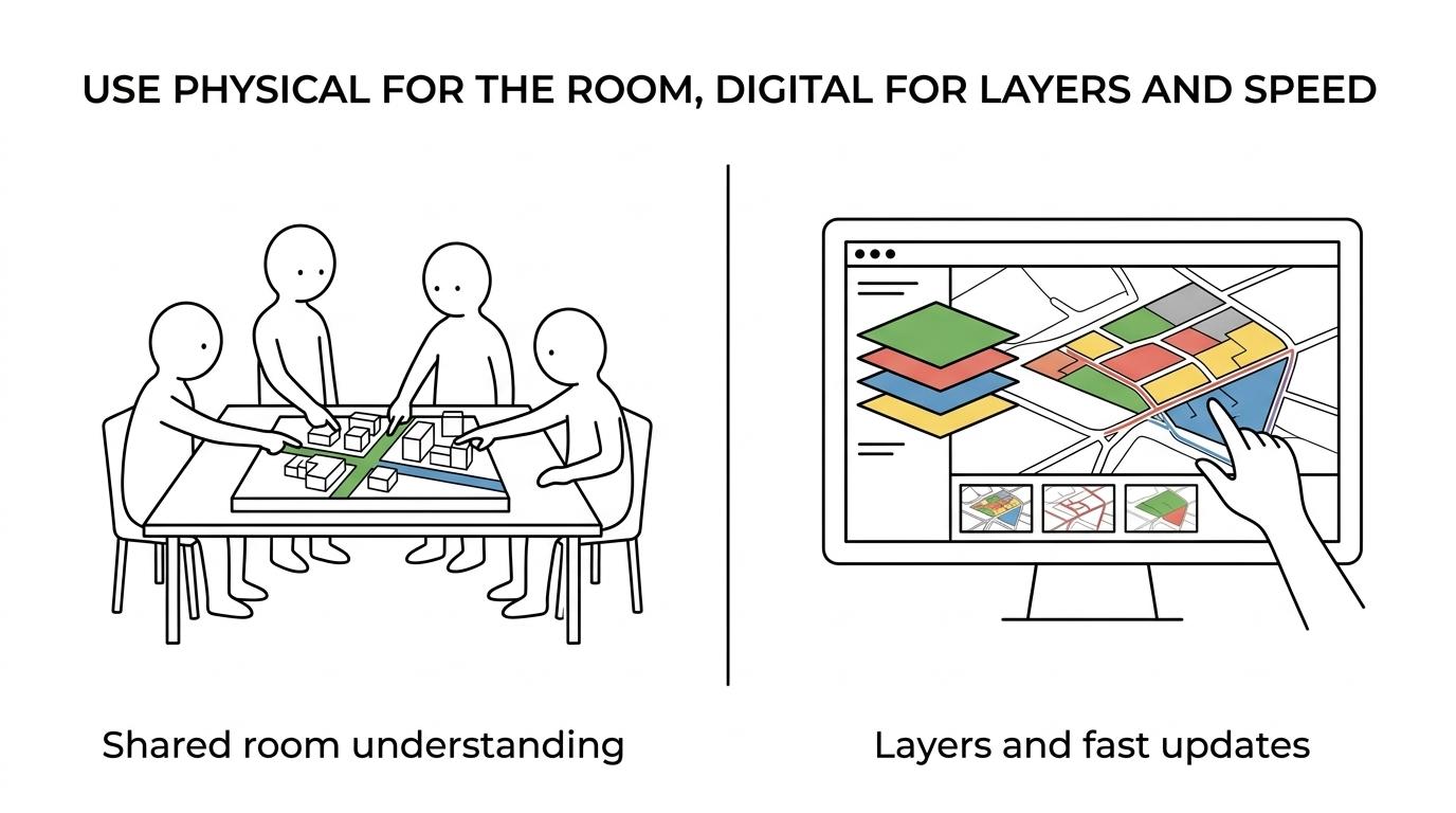
Digital tools are stronger where schemes change daily, consultation must happen online, or transport, sunlight and data layers need live interrogation. GOV.UK guidance on digital community engagement notes that visual and map-based tools can make complex planning information easier to understand and can widen participation.
The trade-off is simple. If the question is, "Can everyone understand this place together?" physical often wins. If the question is, "Can we test twenty versions quickly and publish them online?" digital often wins. In many cases, the best answer is both.
How do you brief a town planning model project so it answers the right planning questions?
A strong brief starts with decisions, not materials. Say what the model must help people decide, and the technical choices become much easier.
Step 1 is to define audience and use case. A public consultation model, a design review model and an exhibition model can describe the same scheme but need different emphasis. If councillors are the audience, legibility and context may matter more than façade texture. If transport teams are involved, movement routes and junction logic may need priority.
Step 2 is to define the content hierarchy. Decide what is essential, optional and unnecessary. This is where terms like site context, public realm, landmark views, phasing and traffic control should be made explicit. ARI Model’s category experience is relevant because these are standard masterplan and city-model decisions, not last-minute decorative choices.
Step 3 is to define operations. Ask who will approve CAD data, who checks planning boundaries, how the model will travel, where it will be displayed, and whether lighting or interactivity is needed. Pro tip: many model problems begin as file-management problems, not fabrication problems.
Should a town planning model show every building or only key massing?
Most town planning models should show full context but selective detail. The aim is not maximum information. It is decision-grade information.
Existing context usually needs enough recognisable form to orient the viewer. Key landmarks, topography shifts, important public buildings and major movement corridors should read clearly. Proposed elements need enough distinction to reveal height, block structure, frontage and public space.
Use this rule of thumb:
- Keep in detail: landmarks, development parcels, streets, public realm, phase boundaries
- Reduce in detail: repetitive background buildings, minor roof furniture, non-critical façade texture
- Highlight clearly: changes to access, edges, gateways, civic space, transport interfaces
A common misconception is that more detail always means more credibility. In planning, too much detail can blur the real issue. If a model hides a weak urban structure behind attractive surface treatment, it is less useful, not more useful.
What mistakes reduce the value of a town planning model?
The biggest mistakes are wrong scale, unclear purpose, visual bias and poor context modelling. Each one weakens trust and slows decisions.
One problem is treating the model as a static display rather than a working planning tool. If the team cannot point to the exact choices the model is meant to inform, the brief was too vague. Another problem is failing to model enough surrounding context. A block may look convincing in isolation but fail badly once adjacent heights, streets or public spaces are visible.
Bias is another risk. If proposed buildings are highly refined while the existing townscape is reduced to a rough base, viewers may feel the presentation is trying to win approval rather than support open discussion. That matters in UK consultation settings, where transparency and fairness shape trust as much as design quality does.
The final trap is poor update discipline. Town planning schemes change. That problem is compounded when the base information is weak in the first place, and 4CAD’s work on dokumentace skutečného stavu shows why many teams now put more emphasis on accurate existing-condition capture before a physical model is updated or rebuilt. If the model lags behind current drawings, confidence drops quickly. A better approach is to decide early which elements must stay fixed and which can be revised as design and consultation feedback come in.
---